This one is gonna be a long one, folks. If you want to hear about my face vs. a rock, skip to the end! But be warned, you’ll miss some amazing photos and a few stories of “trail magic”.
- Total miles: 9.55
- Total “hiking” time (includes summit stops, but not the overnight): 12 hours, 35 minutes
- Total feet ascended: 3,865
I had a weekend free and thought I might try out my first solo backpacking trip before winter hits and it gets too cold. Liberty Springs tentsite isn’t too far from a trailhead, and meant I could “peakbag” both Liberty and Flume. As always with hiking in New Hampshire, I kept an eye on the weather as the weekend approached. The forecast called for an overnight low of 38. On my practice camping trip, it hit 40 and I was fine. So off I went.
I arrived at the trailhead around noon. I was worried I wouldn’t get a parking spot with such a late start, but the lot was only 1/3 full. I donned my full backpacking pack. Which weighed in at 25 pounds. Significantly heavier than my daypack, which comes in around 13 pounds. 3 hours, 13 minutes, 3.21 miles, and 2,428 feet of ascent later, I got to the Liberty Springs Tentsite.
I set up my hammock.

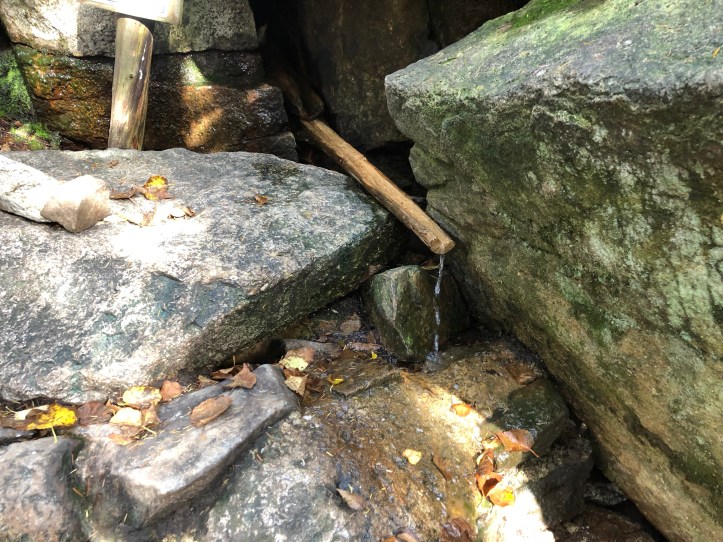
Got some water at the spring (and filtered it).
Made myself dinner. And heard the tentsite caretaker say the overnight temps were going to be 20s and 30. Crap. And the temperature started to drop. And drop. I did pop out of my hammock for a few minutes to see this amazing sunset.

The next morning, Sunday, I got up, made some coffee, and leaving my hammock, sleeping bag, and food stuff behind at the tentsite, I “slackpacked” up to Liberty and Flume.
Now I always read the descriptions of trails before I go. The Flume has an approach that is the Flume slides. I did not take that approach as a slide is basically a steep field of loose rocks on the side of a mountain. Instead I’d summit Liberty, then hike over to Flume from the other side. No problem, right?
After more ascent (roughly 500 feet in 1/2 mile), you get to the Alpine Zone and then suddenly pop out on granite slabs and a fantastic view. It was also windy and a little bit make you pee your pants high.

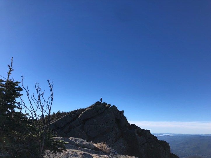
But you aren’t at the top yet. From this point, you still have to climb over a giant boulder, which then STILL isn’t the peak. See that little speck on the top of this rock? THAT’s the peak. And I have to get over this narrow bit of rock to get there. Did I mention that it was windy?
I would later find out that is Taylor. He and the person he was hiking with (whose name I’ve just forgotten, let’s call her Hiker #2) were at the peak. I sat at this spot for a good five minutes working up the courage to cross this rock. Hiker #2 waved at me. I yelled over, “Are you coming this way?”. She replied that they were. I told them I’d take their pictures and send them to them. Knowing that they were there helped me. I also argued with myself about doing things that terrify you. I also spied a little cheater path that I would still have to cross a tiny bit of this terrifying rock, but then could drop down the side where there were trees. I am 100% sure that I wasn’t supposed to take that path, which I didn’t realize until 10 feet in when there were rocks and a tree “blocking” the path. This small “ledgy” bit was far scarier than the ascent up to where Taylor is in the above photo. Which I made it to. And got their info and sent them the photos!
The views from Liberty were amazing, which for whatever reason (that I’m sure had nothing to do with how terrified I was) I didn’t do a good job of capturing on camera.
Also while on Liberty’s summit, I met Nancy. Who had just come up not far behind me, from the same trail I had taken. She was also headed over to Flume. And was also hiking solo, so she suggested we both go over together. After my terror of Liberty, I was happy to have a hiking buddy.

The view of Flume from Liberty. Note the grey patches on the front, those are slides. No, thank you.
Flume (from the not slides) was far less terrifying that summiting Liberty. Even descending Liberty had a couple of nerve-wracking “butt slides” to get down. But we made it!

The view back to Liberty from Flume. From Flume, I would trace back my path to Liberty and back to the tentsite. At some point after Flume, Nancy hiked on (she was faster than me). EDIT: Forgot to say that on my way back, I conquered that rocky ledge and crossed it without the cheater path!
Back at the tentsite, I packed up my stuff and prepared to hike back to the trailhead. While packing, Kate and Andrew sat down on the tent platform to make lunch. They were doing a 3-day Pemi Loop, a 31-mile hike in the White Mountains (including Liberty and Flume, hence their pitstop). Unfortunately, the weather was going to be much colder Sunday night, they hadn’t hiked the Whites before, and they had a hard stop of Monday. They asked me about the possibility of getting rides at the Liberty Spring Trailhead, in case they didn’t make the full loop. I offered them a ride if they wanted one today (they didn’t) and also magically got cell service just as I was leaving and gave them the website for a hiker taxi that I’d heard about. Yay! Good deed #1. I donned my once again 25 pound pack and headed out.
Important to the rest of our story, Liberty Spring Trail, like nearly every trail I’ve taken in the Whites, is rocky. Not like “oh there are some rocks on this dirt path” rocky, but the actual path is rocks. Large step-like rocks, big round boulders, small sharp wedges of rock rocky.
As I descended down to the trailhead, a young pair of hikers passed me. They had very light packs and were moving quickly. It’s not uncommon for people to “trail run”. They may carry a bottle of water and very small packs and zip up and down the trails. Just earlier in the day I wondered what happens if something goes wrong? My day pack alone is 13 pounds of mostly “just in case” items. Well, not long after passing me, I heard the girl yell. I caught up to them and she had twisted her ankle. FINALLY MY PACK HAS A REASON FOR LIVING. I gave her Advil, my Ace bandage, and one of my poles. I knew I couldn’t give her both as I wasn’t sure I’d make it, but I happily offered one. She took the Advil, wrapped her ankle, gratefully accepted a trekking pole, and made it down off the mountain (and still managed to be faster than me, but happily that meant she finished first and left the pole at the trailhead). Yay! Good deed #2.
Liberty Spring Trail is also part of the Appalachian Trail. And even though it’s late in the season for NOBOs (north bounders), I saw three come up. On the last thru-hiker, I asked, “Are you thru-hikers?”. He said yes and I asked “Are you all together?”. They had some space between them. He said yes. I asked “Would you like the rest of my Skittles?”. That was a big yes. So I handed him my candy and told him to share with his friends. He replied, “trail magic!”. Yay! Good deed #3!
Suddenly behind me, I hear people. It isn’t uncommon for me to get passed, but this time it was Andrew and Kate! They decided that with their timing and the weather, they’d be better off stopping today and getting a ride to their car. I was happy to oblige, so we continued hiking down together. Yay! Good deed #4!
With all the medical supplies and rides, Kate said I was the “Mother Teresa of the Trail”. When you hike the Appalachian Trail, you often take a “trail name”. I feel like mine may have just been decided.
Now, as they say, no good deed goes unpunished. And my friends, that was 4 good deeds done today. We were 1/2 a mile to a mile away from the car. The trail was leveling out, but still plenty rocky. I had just joked “Are we there yet?” when something happened. I’m not sure what. Though the fall happened in slow motion, I don’t know what triggered it.
I misstepped, clearly. My feet were not on top of the next rock, but in front of it. As I fell, my knees hit the first rock. Then the rest of me started falling forward. My trekking pole sort of got stuck, and my hand couldn’t reach out in front of me to stop falling. My right arm (currently pole-less since I had given mine to the twisted ankle hiker) hit across one of those wedge rocks I mentioned earlier. Then as my face approached yet another f-ing rock, a part of my brain was like “it’s cool, most of the momentum has ended, you can probably stop thi–oh, fuck, your 25 pound pack”. And my 25 pound pack smashed into the back of my head, driving my face into a giant granite step.
Thankfully, Andrew and Kate were with me and helped me pull myself together. We got to the trailhead and grabbed my other pole. We got to the car, I gave them a ride back to theirs. I’m home now and have assessed the damage. My arm, knees, and face are scraped and bruised. Maybe my trail name should be “Rock Face”.

[…] back in 2018, when I did this trip the first time, I described this rocky ledge/scramble part. As we got here, the Bartender asked if this was the […]
LikeLike