OK so I’ve got photos and a nice little description of our hike, but the best part is what happened after we got to the summit.
Rainbow, Right Turn, Ruth (no trail name yet), and I set out to hike Mt. Shaw. Right Turn had previously attempted Mt. Shaw, but took an unofficial (and therefore not maintained) trail, where she and some other hikers ended up bushwhacking (going off trail). She didn’t end up getting to the summit that day. Today, we opted to take the trail from Castle In the Clouds. It’s the same trailhead starting area that I took for Mt. Roberts.

Right Turn’s bushwhack is a useful example of why I do lots of research on my hikes, even “easy” ones. The only trail listed in All Trails for Mt. Shaw is the unofficial one. It starts on private property and isn’t maintained, doesn’t appear on maps, and doesn’t have signage. The official trails can be found in the 52 With a View book or on the Lakes Region Conservation Trust maps. They’re well marked and maintained. We took the route suggested in the book, which does involve several trails and junctions (THIS WILL BE IMPORTANT LATER).
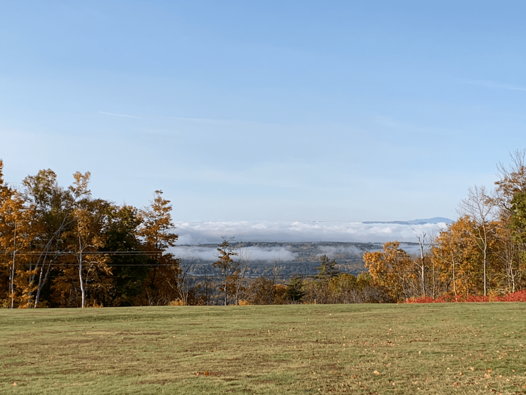
Aside from several trail junctions to look out for, it’s a very lovely hike. Never too steep, no rock scrambles, or scary ledges. A nice long-ish walk in the woods. The top of Shaw has a small loop on it, leftover from when there was a carriage house on the top. The loop is the old carriage road. You turn a corner and come to this very lovely view.

A fantastic view of LOTS of 4000 footers and many other 52 with a view summits. If you zoom in, Washington is left of center with snow on the summit. Several other mountains were visible as well. Some obvious, like Chocorua. Others invited great debate. Amongst the four of us, which included the consulting of an app that you can hold up against the horizon. But also with a couple that arrived shortly after us, and then another two hikers after that. Every single person rounded the corner, pointed out Washington, and then began debating what some of the other summits were.

L to R: me, Right Turn, Rainbow, Ruth
The four of us had a lovely lunch break, and then began to head back. Being a patch chaser, I noted that Black Snout was not too far of an added spur, and would count towards the LRCT’s Hiker Achievement Patch. Right Turn said her hip was bothering her a bit, so she would hike down and wait for us at the trailhead (we had burgers and beers planned!). Ruth said she’d go down with her. Since no one would be left alone, Rainbow and I set off for Black Snout, while Ruth and Right Turn headed down to the trailhead.
Rainbow and I would be adding 2 miles to our hike as a “spur”, from the out and back route we had all taken up to Shaw (and then back to the cars).
The walk over to Black Snout was lovely. We passed this…unique trail marker.

The trail was grassy and mostly flat. It pops out on Black Snout, which had its own nice views. Not the spectacular view of other mountains, but instead lots of water.

Shortly after we left Right Turn and Ruth, it occurred to me that it may not have been the BEST idea to split up, given Right Turn’s … special talent and reason for her trail name, which is namely, going the wrong way.
But what’s done is done. Rainbow and I returned to the junction where we had left Right Turn and Ruth and hiked back down toward the trailhead. About a mile from the trail head, we came to a junction. And there were Right Turn and Ruth! They had missed one of the previous junctions, and ended up taking a much longer route, ending up at the junction just a few minutes before us. At least Right Turn lives up to her trail name.
We finished the hike and Rainbow and I had hiked 9 miles (and hit an additional summit), while Ruth and Right Turn hiked 10.4. But hey, they seemed to have a nice hike and got to cross a bridge that we didn’t get to see.
Stats:
- Distance: 9 miles (Rainbow & myself), 10.4 miles (Right Turn & Ruth)
- Elevation gain: 1,936 feet (Rainbow and myself)
- Total time: 5 hours, 38 minutes (all of us)
- Moving time: 5 hours, 1 minute (Rainbow and myself)